1/4


Anchor Alarm - SailGrib AA
1K+下载次数
43.5MB大小
3.2(06-10-2023)最新版本
详情评价版本信息
1/4
Anchor Alarm - SailGrib AA介绍
SailGrib制作的锚警报,是一款功能齐全的现代锚警报应用。
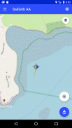
-在锚点之前启动应用程序,该应用程序将在地图上记录并绘制您的轨迹。
-将手机放在图表表上。
-无需担心应用程序的摩尔。
-返回应用程序。在赛道上,找到锚定时与船的位置相对应的点。由于锚定后的反向运动,您应该能够在地图上相对容易地检测到它。
-使用屏幕中间的目标符号将地图中心定位在锚点上。
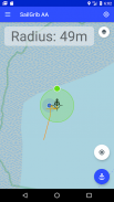
-按下蓝色的“锚点”按钮以固定锚点位置。
-通过将绿点移到该区域的边缘来调整润湿区域的半径。
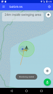
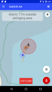
-再次按下“锚点”按钮修复润湿区域,该区域变为绿色。警报被激活。
新:在应用程序内使用您的Navionics划船图!
使用高级选项:
-在屏幕上定义一个六边形且可编辑的润湿区域。
-发生警报时发送邮件。
-查看SailGrib WR地图。
-如果您在润湿前忘记启动应用程序,请导入SailGrib WR的GPX跟踪。
该应用程序在后台运行,并使用最新的Android技术来降低功耗,同时最大程度地提高定位精度。
请注意,位置的准确性取决于您的手机和位置。自2021年3月起,我们认为大多数手机在海上时的精度在2至10米之间。
Anchor Alarm - SailGrib AA - APK信息
APK版本: 3.2程序包: com.sailgrib.anchoralarm名称: Anchor Alarm - SailGrib AA大小: 43.5 MB下载次数: 26版本: 3.2发布日期: 2024-06-10 01:00:17最小屏幕: SMALL支持的CPU:
程序包ID: com.sailgrib.anchoralarmSHA1签名: 8A:3C:27:CE:6B:3E:A3:52:0F:A4:19:47:54:A4:C7:ED:F7:C9:E8:72开发商 (CN): Henri Laurent组织 (O): sailgrib本地 (L): Paris国家/地区 (C): FR州/市 (ST): 程序包ID: com.sailgrib.anchoralarmSHA1签名: 8A:3C:27:CE:6B:3E:A3:52:0F:A4:19:47:54:A4:C7:ED:F7:C9:E8:72开发商 (CN): Henri Laurent组织 (O): sailgrib本地 (L): Paris国家/地区 (C): FR州/市 (ST):
Anchor Alarm - SailGrib AA的最新版本
3.2
6/10/202326 下载次数13 MB 大小
其他版本
3.1
1/9/202326 下载次数13 MB 大小
3.0
20/5/202326 下载次数13 MB 大小
2.5
14/4/202126 下载次数13 MB 大小


同类应用


English


